CONTEC has been as a top satellite image data processing and satellite image distribution service as a whole-ground integration solution provider in South Korea.
CONTEC Satellite Image Data Processing
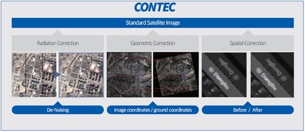
Satellite images are processed on the ground using image processing techniques (radiometric, spatial, and geometric) based on the characteristics of satellite systems. This correction adjusts for physical displacement due to the characteristics of the satellite system and distortions caused by orbit, Earth’s curvature, etc., producing standardized image products.
- EO Satellite Image Processing: Applying specialized algorithms to correct distortions in raw image data received from satellites, their satellite image processing technology produces standardized image products. This technology includes radiometric, spatial, and geometric distortion correction for the creation of standard images from satellite data, enhancing overall image quality.
- SAR Satellite Image Processing: SAR satellite image processing demands various knowledge and expertise, encompassing the satellite’s orbit, SAR satellite operating modes, and SAR system characteristics. CONTEC offers the advanced Contec SAR-P solution, incorporating a crucial precision matching filter for high-resolution image processing in the Azimuth direction. This solution is specifically designed to process Spotlight and Sliding Spotlight images with exceptional precision.
CONTEC Satellite Image Distribution
CES (CONTEC Earth Service) serves as a global satellite data provider, supplying imagery from versatile practical satellites as well as various international satellites to customers worldwide. In the future, CES plans to provide imagery from CONTEC’s EO satellite (March 2024), ES satellite (2nd quarter of 2025), and small satellite constellation (starting from 2026) through its proprietary ordering system.
- Provision of KOMPSAT Satellite Imagery: Operated by the Korea Aerospace Research Institute (KARI), the Earth Observation satellite constellation includes various optical (EO) satellites, such as KOMPSAT – 2/3/3A , and synthetic aperture radar (SAR) satellite KOMPSAT-5, with diverse spatial resolutions.
- Provision of ICEYE Satellite Imagery: The ICEYE satellite possesses a high-resolution small synthetic aperture radar (SAR) constellation (ICEYE-X Series) and provides reliable, timely, and accessible Earth Observation data. In 2023, Contec signed a satellite image provision contract, actively collaborating to expand the radar image provision business area for mutual growth.
- Provision of CONTEC Oreum-Sat Satellite Imagery: Contec-Sat (Oreum) satellite is an EO satellite currently under development by CONTEC. It observes wide areas to assess urban development, monitors disaster-prone areas, observes marine ecosystems, and predicts crop yields.
If you are looking for a satellite image data processing and distribution service, you can find them at CONTEC.
Click here to contact CONTEC
View more: Satellite Image Data Processing and Satellite Image Distribution Service


